LiDAR Surveys | Topographical Surveys | Elevation Models
3D Models | Volumetric Calculations | 2D Orthomosaics
“The experience with The Drone Co was a positive one and the data collected extremely useful and an effective alternative to conventional LIDAR.”
Oliver Monk – Solihull Council – Highways Division
Photogrammetry and Topographical Data using our advanced systems.
We use a variety of both fixed wing and multi-rotor aircraft to capture data. Both drones have their advantages and it mainly depends on what size area you are looking to collect data for. For structures, we use multi-rotor platforms to capture more oblique images which would not be possible from a fixed wing drone. For large survey areas, we use fixed wing areas as they capture the data faster and with greater endurance.
Just some of our recent case studies…
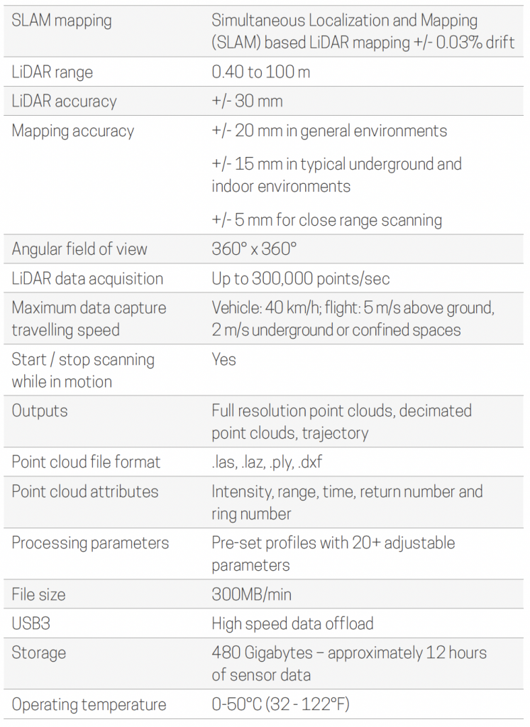
LiDAR
Hovermap
A versatile LiDAR scanning solution, makes mapping of inaccessible areas safe, easy and fast. Designed as a drone payload, Hovermap combines advanced collision avoidance and autonomous flight technologies to safely and rapidly map hazardous and GPS-denied environments. Hovermap captures high resolution point clouds when flying, driving or walking.
Hovermap combines a rotating LiDAR sensor, which captures a near 360° x 360° spherical field of view, with simultaneous localization and mapping (SLAM) algorithms for mapping, navigation, collision avoidance and position hold capabilities without a GNSS positioning system.
When mounted on a drone, Hovermap enables autonomous flight—beyond line-of-sight and communication range—in challenging GPS-denied environments, making it possible to venture farther into inaccessible areas.
When using Autonomy Level 2 flight mode, we can fly an entire mission, from take-off to landing, using a tablet and smart waypoints. Data is processed on-board in real-time to stream a 3D map back to the operator, while Hovermap navigates to waypoints, avoids obstacles, and captures high resolution, accurate point cloud data.

Click through the specification tabs to the right


BENEFITS

IMPROVED SAFETY
Keep personnel away from edges, confined spaces or heights. Fly Hovermap beyond line-of-sight and capture critical data to assess the condition of assets and improve safety decision-making.

PRODUCTIVITY & EFFICIENCY
Quickly and safely map inaccessible areas and assets with minimal disruption to operations. Fly, walk or drive Hovermap to capture data where and when you need it.

GREATER INSIGHTS
Explore and map inaccessible areas. Hovermap’s beyond line-of-sight flight enables capture of accurate, high resolution point clouds without shadowing and delivers greater confidence in analytical or modeling outputs.

COST & TIME SAVING
Hovermap pilots can fly an entire mission from take-off to landing using a tablet, with minimum training. With Hovermap it takes a few minutes to image complex assets that would take hours using traditional survey techniques.
Why choose The Drone Company?
Just some our benefits…
Sensor Flexibility
We have a wide range of sensors for a variety of different applications. If you require standard photo survey or promotional images, we can provide you with both large DSLR platforms and zoom cameras. If you require a thermal drone survey, we have a number of thermal sensors that we can use on our aircraft.
Special Operating License
The Drone Co have a special operating safety case (OSC) from the Civil Aviation Authority (CAA) which enables us to operate in congested areas within 10m of any person, vessel or vehicle not in our control. This has been awarded as we are able to prove how we can operate safely with these reduced distances.
Multiple Teams
We have the capacity to undertake large contracts with a large number of pilots based across the country ready to be dispatched. This also enables us to remain cost competitive across the UK. We also travel globally.
Drone Technology
Using state of the art software and our fully programmable fixed wing drones, we are able to accurately scan and map areas of several square kilometres with ease. This can be done with little setup time and fast turnaround from data collection to data processing.
Credentials
We have worked in a variety of different locations, climates and countries working with some of the largest companies in the world. Our experience enables us to overcome challenges and barriers that enable us to come up with new and innovate solutions to our clients problems.
Processing and Data Outputs
The Drone Co use state of the art photogrammetric, GIS and 3D CAD software to form centimetre accurate computer models of the topography. All our data is exportable into almost any 3D CAD software as we have standardised all our outputs to fall in line with existing data.
Special License
The Drone Co have a special operating safety case (OSC) from the Civil Aviation Authority (CAA).
Insured
We operate with £10 million Public Liability Insurance which can be increased upon request.
Quick Deployment
We operate frequently on last minute notice with our drone operators based around the UK available at short notice.
We pride ourselves in finding new and innovative ways to capture and process our drone data. We are constantly updating the equipment and systems to ensure we as a drone operator, are providing our clients with the best possible service. Drones as a surveying tool are extremely effective and efficient in comparison to traditional surveying techniques. This is why The Drone Co is constantly challenging existing suppliers and competing with them and winning big contracts.
Our operating limitations are set depending on the job required. We can operate with our standard permissions which are set to 30m at take-off and 50m during flight, or we can utilise our operating safety case which allows us to reduce those distances to 10m at take-off. This reduced distance is because we have proven to the CAA that we can operate safely from these distances and we have input the procedures to operate our drone safely with this extraordinary license.